
Agriculture Inspections and Land Surveying
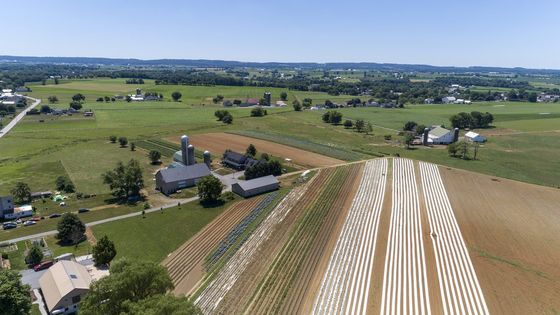
Using drones for agricultural inspection can provide you with accurate, useful, and actionable data about your crops. This service allows quick and easy tracking, especially on large farms. You can easily track changes in crop health and estimate crop yields with aerial photography. It can also be used to plan irrigation system installation and repairs as well as drainage for agricultural properties among other purposes. On the most basic level, aerial photography for farm inspections give you a birds-eye view of your crops and allows you to inspect your farms in ways that are not possible at ground level.
Crop Inspections
With Agricultural aerial inspections, farmers and agronomists will be able to carry out a detailed and comprehensive inspection of their crops. This can be scheduled as often as you like with accurate data about your crop status at any given time. This helps to improve the process of crop management and to detect potential problems long before they even appear. Agricultural crop inspection makes it possible to inspect crops quickly. Data collected can also be used to develop valuable crop maps that make it possible to manage your crops better.
Aerial Photos and videos
Our advanced Aerial solutions for agricultural purposes provides a bird-eye view of your entire agricultural property from angles that you cannot see from the ground. We can provide you with pictures, videos, or both as the case may be. All photos and videos are high resolutions which provide the most detailed look of possible hard to reach areas. The pictures and images generated can serve several agricultural planning purposes including the proper planning of drainage and irrigation systems among other purposes.
Advanced Aerial Solutions for agricultural inspections
Our advanced aerial solutions will help you plan easily and more effectively for your farmland. They also make a land survey for agricultural planning more effective. We can provide detailed data and analysis including the area, volume, elevation, and other measurements that prepare 2D and 3D maps possible. We can also use drones with Normalized Difference Vegetation Index (NDVI) capabilities which allows us to take images in both the visual and the on the near-infrared spectrum that can provide critical data that can be used to determine plant health.
Professional Aerial Agricultural inspection service
As a farmer who has seen advantage of Aerial inspection and wants to start using drones for agricultural inspection, there are two main ways to go about it. You can purchase your own drones, get the education training needed to operate it yourself, and get the required certification. You’ll admit this is an unnecessarily difficult process. The best alternative would be to hire
Kitchener Aerial Surveying to get access to all the information you need. We have a team of professionals and high-quality drones and we can assist you through your agricultural aerial inspection.